Mount St Helens had a terrible eruption happen in 1980. Mount St. Helens is an active stratovolcano in Skamania County, Washington. This volcano is in the Pacific northwest region. St. Helens is one of the volcanoes in the Cascade Volcanic Arc, and the Cascade Arc is part of the Pacific Ring of Fire. Known for its ash explosions and lethal pyroclastic flows, Mount St. Helens is still a threat to us today. It’s one of the well-monitored volcanoes, because it is still active. Mount St. Helens is over 40,000 years old, and before the eruption in 1980, was 4,200 miles high in altitude. It is located 45 miles west of Mount Adams (St. Helens’ brother mountain) and 50 miles from Mount Rainier. Today, there is a huge crater on the side of the mountain from the eruption in 1980. The crater is 1-2 miles wide and is 0.5 miles deep. Today the mountain includes layers of basalt, and andesite, from previous eruptions. Also the active volcano’s magma chamber is inter layered with ash, pumice, and lava.
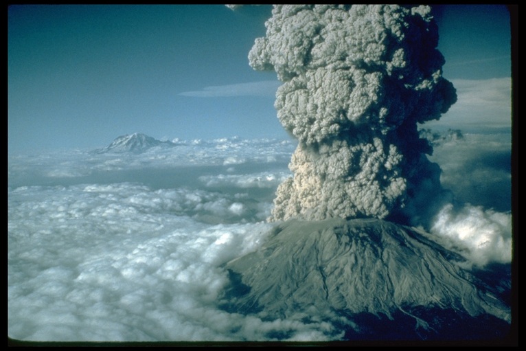
Before the eruption in 1980, Mount St Helens was the fifth highest peak in Washington. On March 20, 1980, there was an earthquake that measured a 4.2 on the Richter scale. Then, on March 27, steam venting started on the top of the volcano. Towards the end of April, the North side of the mountain started to bulge outwards. Then, on May 18, 1980, at 8:32 a.m., a magnitude 5.1 earthquake collapsed the north flank of the mountain. This triggered a debris avalanche that contained ice, snow, parts of land, and water which are called lahars or volcanic mudslides. The volcano exploded into pyroclastic flows that covered over 230 square miles. More than 1.5 million metric tons of sulfur dioxide were released into the air. After 9 hours, the violent ash cloud had reached 12 to 16 miles above sea level. The eruption ejected 24 megatons of thermal energy. In the end, the devastation was great. 57 people were left dead, 250 homes, 47 bridges, 15 miles of railroad, and 185 miles of highway were destroyed. This volcano today is absolutely a definite threat to us, and is still being monitored using seismographs, and other technology that volcanologists use.
Before the eruption in 1980, Mount St Helens was the fifth highest peak in Washington. On March 20, 1980, there was an earthquake that measured a 4.2 on the Richter scale. Then, on March 27, steam venting started on the top of the volcano. Towards the end of April, the North side of the mountain started to bulge outwards. Then, on May 18, 1980, at 8:32 a.m., a magnitude 5.1 earthquake collapsed the north flank of the mountain. This triggered a debris avalanche that contained ice, snow, parts of land, and water which are called lahars or volcanic mudslides. The volcano exploded into pyroclastic flows that covered over 230 square miles. More than 1.5 million metric tons of sulfur dioxide were released into the air. After 9 hours, the violent ash cloud had reached 12 to 16 miles above sea level. The eruption ejected 24 megatons of thermal energy. In the end, the devastation was great. 57 people were left dead, 250 homes, 47 bridges, 15 miles of railroad, and 185 miles of highway were destroyed. This volcano today is absolutely a definite threat to us, and is still being monitored using seismographs, and other technology that volcanologists use.